When outdoor enthusiasts and cycling aficionados talk about the best rail trails in America, the Silver Comet Bike Path invariably enters the conversation. This magnificent 61.5-mile paved pathway stretching across northwest Georgia has transformed from a forgotten railroad corridor into one of the Southeast’s most beloved recreational destinations. Whether you’re a serious cyclist training for your next race, a family seeking a safe outdoor adventure, or a history buff fascinated by the golden age of railroads, the Silver Comet Bike Path offers an unforgettable experience that combines natural beauty, Southern hospitality, and a rich transportation heritage.
The Journey: Length and Route of the Silver Comet Bike Path
The Silver Comet Bike Path begins in Smyrna, Georgia, just northwest of Atlanta at the intersection of South Cobb Drive and the East-West Connector. From this suburban starting point, the trail winds westward for 61.5 miles through three counties—Cobb, Paulding, and Polk—before reaching the Alabama state line near the small community of Esom Hill. The entire route is paved with a smooth, 12-foot-wide surface (concrete in Georgia), making it accessible to cyclists, inline skaters, runners, walkers, and people with disabilities.
What makes the Silver Comet Bike Path particularly special is its gentle grade. As a former railroad corridor, the trail maintains the gradual inclines necessary for train travel, which translates into a predominantly flat experience for trail users. This characteristic makes it ideal for riders of all skill levels and ages. Unlike many cycling routes that challenge riders with steep hills and demanding climbs, the Silver Comet allows users to focus on distance and endurance rather than elevation gain.
The trail passes through a diverse landscape that evolves as you travel westward. The eastern sections near Smyrna are more developed and suburban, with good access to amenities and services. As you progress west through Mableton, Powder Springs, Dallas, Rockmart, and Cedartown, the surroundings become increasingly rural. Users are treated to scenic vistas of preserved forests, cotton fields, wetlands, and farmland. The trail also features historic trestles, a 800-foot tunnel through Brushy Mountain, and fascinating geological formations that tell the story of Georgia’s ancient past.
A Two-State Trail System: The Chief Ladiga Connection
One of the most remarkable features of the Silver Comet Bike Path is its seamless connection to Alabama’s Chief Ladiga Trail at the Georgia-Alabama state line. This connection, completed in December 2008, creates one of the longest paved rail trails in the United States, spanning approximately 94-100 miles depending on recent extensions (with Anniston’s 2025 extension, the total length now exceeds 105 miles).
The Chief Ladiga Trail, named after Chief Ladiga (pronounced la-dye-ga), a leader of the Muscogee (Creek) Nation who signed the 1832 Treaty of Cusseta, extends for approximately 33-40 miles from the state line to Anniston, Alabama. The trail was built along the same former Seaboard Air Line Railroad corridor that the Silver Comet follows. In April 2025, Anniston celebrated the opening of a 6.5-7.1 mile extension that brings the trail directly to the city’s downtown Amtrak Multimodal Center, creating a truly unique rails-to-rails connection where trail users can literally ride from a trail onto an active passenger rail station.
Together, the Silver Comet and Chief Ladiga trails were inducted into the Rails-to-Trails Conservancy’s Hall of Fame in 2009, recognizing their significance as premier examples of successful rail trail conversion. The combined system represents one of the first cross-state trail connections in the country and serves as a model for interstate trail development nationwide.
The Alabama portion of the trail offers its own distinctive character. The first thirteen miles from the state line travel through the stunning Talladega National Forest and the southern foothills of the Appalachian Mountains, providing awe-inspiring vistas and impressive rock formations. Cyclists can catch glimpses of Dugger Mountain, Alabama’s second-highest peak, and Mount Cheaha, the state’s highest point. The trail passes through charming Alabama communities including Piedmont, Jacksonville (home to Jacksonville State University), and Weaver before reaching Anniston.
For ambitious cyclists, completing the entire Silver Comet-Chief Ladiga system in a single day is an achievable goal that provides a profound sense of accomplishment. Many riders tackle the approximately 94-100 mile round trip (or arrange shuttle services for a one-way journey), experiencing the beautiful transition from Georgia’s countryside to Alabama’s mountain foothills.
Cities and Communities Along the Silver Comet Bike Path
The Silver Comet Bike Path connects and revitalizes numerous communities along its route, each offering unique attractions, services, and Southern hospitality to trail users.
Smyrna serves as the eastern gateway to the trail. This suburban city provides excellent access to the trail with parking, restrooms, and the Silver Comet Depot, a converted train depot that now offers bicycle and skate rentals, accessories, and concessions. The city has embraced the trail as a community asset, and the surrounding area features significant residential and commercial development that has benefited from proximity to the trail.
Mableton offers Heritage Park, an extensive nature preserve with over 100 acres of native plant gardens, vibrant wetlands, and historic mill ruins. The park’s boardwalks and trails wind along Nickajack Creek, and visitors can also access the nearby Concord Covered Bridge, a historic structure that adds to the area’s charm.
Powder Springs provides access through the Wildhorse Trail, a two-mile wooded spur that leads to a popular county park featuring Seven Springs Water Park and a BMX bike track. This connection showcases how the Silver Comet integrates with local park systems to expand recreational opportunities.
Dallas is home to one of the trail’s most impressive engineering features: the 1901 Pumpkinvine Creek Trestle. Rising 126 feet and spanning 750 feet over Pumpkinvine Creek, this restored trestle marks the gateway to more remote sections of the trail as it traverses the 25,000-acre Paulding Wildlife Management Area. The trestle is located less than a mile west of the Rambo Road Trailhead.
Rockmart, approximately 37.6 miles from the Smyrna trailhead, offers a delightful “trip back in time” experience. The Silver Comet Trail combines with the town’s Riverwalk Park in a curvy section featuring historic sites, interesting buildings, and places to eat. Trail users frequently praise Rockmart’s authentic small-town atmosphere and convenient access to restaurants and shops. The nearby Coot’s Lake Beach Trailhead (at mile marker 33.5) provides the closest parking to the historic Brushy Mountain Tunnel, a massive 800-foot tunnel built in 1912 that cuts through the hillside.
Cedartown has earned particular acclaim from trail users for its welcoming spirit and engagement with the trail community. The town maintains a Welcome Center at a restored depot where cyclists can learn about the area, get directions, and enjoy picnic facilities. The city manager and local historians actively greet and assist trail users, sharing stories about local heritage including connections to the Trail of Tears at Great Springs Park. Many cyclists cite Cedartown as a favorite stop along the entire route. The town’s downtown shops and restaurants provide excellent opportunities for refreshment and exploration.
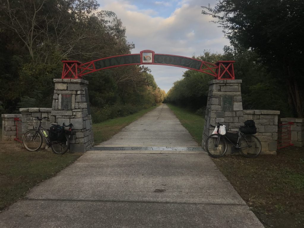
From Cedartown, the trail continues westward through its most scenic and rural areas for the final ten miles to the Alabama state line. The State Line Gateway Park, maintained by Cleburne County, Alabama, features shade, shelters, and a tall stand of pine trees. This spot serves as a popular turnaround point for many riders and marks the official connection point between the Silver Comet and Chief Ladiga trails.
Historical Heritage: From Luxury Train to Community Trail
The story of the Silver Comet Bike Path is fundamentally a story of transformation and adaptive reuse. To understand the trail’s significance, one must first understand the railroad that preceded it and the train that gave the trail its name.
The Seaboard Air Line Railroad
The Silver Comet Bike Path follows the route of the Seaboard Air Line Railroad (SAL), once one of the South’s largest and most important railroad systems. The Seaboard’s history stretches back to 1832 with the chartering of the Portsmouth & Roanoke Railroad, which connected farming operations in North Carolina to major seaports in Hampton Roads, Virginia. Despite early financial difficulties and receivership in 1843, the railroad system grew steadily throughout the late 19th century.
By 1901, the formally renamed Seaboard Air Line Railway had become a formidable southern system stretching from Richmond, Virginia, to Jacksonville, Tampa, St. Petersburg, and Miami, Florida. The company’s expansion into Atlanta came through its purchase of the Georgia, Carolina & Northern and the construction of the Seaboard Air Line Belt Railroad in 1892.
One of the SAL’s final major extensions was building westward from Atlanta to reach Birmingham, Alabama—the section that now forms the Silver Comet and Chief Ladiga trails. In 1902, the SAL acquired the small East & West Railroad (E&W), a narrow-gauge property dating to February 1882. The E&W had opened its first stretch of railroad in October 1882 between Broken Arrow, Alabama, and Esom Hill, Georgia, covering roughly 64 miles. The railroad’s eventual hope was to connect Gainesville, Georgia, with Birmingham.
The Silver Comet Passenger Train
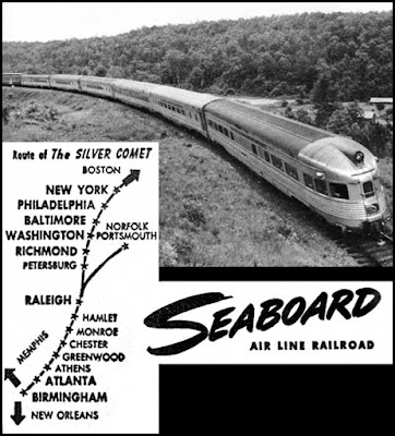
On May 18, 1947, the Seaboard Air Line Railroad launched the Silver Comet, a luxury passenger train that would become legendary in the annals of American rail travel. The Silver Comet represented the pinnacle of passenger rail service during the height of train travel in America. The train was introduced during an era when railroads competed fiercely for passengers by offering ever-more luxurious amenities and faster service.
The Silver Comet operated in conjunction with the Richmond, Fredericksburg & Potomac Railroad (covering Washington, D.C. to Richmond) and the Pennsylvania Railroad (covering Washington, D.C. to New York), with additional connections allowing passengers to reach Boston and Norfolk. The train was listed as #33 (southbound) and #34 (northbound) on the Seaboard and RF&P timetables, while the Pennsylvania Railroad included it as #197 (southbound) and #198 (northbound).
The train featured stunning all-fluted stainless-steel equipment manufactured by the Budd Company, powered by handsome Electro-Motive E7 diesels (later upgraded to E8 models). Passengers enjoyed an array of premium amenities including Pullman-service sleepers, luxurious lounges, elegant dining cars, reclining-seat coaches, and a 48-seat observation car that allowed travelers to enjoy panoramic views of the passing countryside. The train typically averaged 48 mph during its journey and could complete the entire trip from New York to Birmingham in just 23 hours.
As passengers traveled through southern cities like Atlanta and Birmingham on their way to destinations in the North such as New York, Philadelphia, and Washington, they were treated to a variety of scenic vistas. The observation car was particularly popular, offering unobstructed views of the rural landscapes, small towns, and natural beauty of the American Southeast.
However, the Silver Comet faced stiff competition. It was launched years after the Southern Railway’s “Southerner,” which served the same cities and also extended to New Orleans. Moreover, the train entered service during a period when American travel habits were beginning to shift dramatically. The post-World War II boom in automobile ownership and the development of the Interstate Highway System, combined with the rapid growth of commercial aviation, fundamentally changed how Americans traveled long distances.
Decline and Abandonment
In summer 1967, the Seaboard Air Line merged with longtime rival Atlantic Coast Line to form the Seaboard Coast Line (SCL). By this time, passenger rail service nationwide was in steep decline. Unable to remain competitive with automobiles and airplanes, and facing the public’s general shift away from rail travel during the 1950s and 1960s, the Seaboard discontinued the Silver Comet in June 1969. At the time of its final run, the once-luxurious train had been reduced to offering only a single coach, a diner-lounge, and a sleeper—a shadow of its former glory.
The railroad corridor itself continued to carry freight traffic for some time. By 1986, the SCL had merged with several nearby railroads to form the Seaboard System, which became CSX Transportation in July 1987. In 1989, CSX determined that much of the original Silver Comet route through Cobb, Paulding, and Polk counties was no longer economically viable for freight operations. The company abandoned 36 miles of the former rail line, leaving the corridor unused and overgrown.
Rebirth as a Rail Trail
The transformation from abandoned railroad to beloved trail began in 1992 when the Georgia Department of Transportation purchased the former roadbed. Initially, GDOT envisioned using the corridor for a future high-speed transit route. However, later that same year, Ron Griffith, Director of Cobb County Parks, had a different vision. He requested a lease agreement between Cobb County and the Georgia DOT to convert the rail line into a multi-use recreational trail.
The Cobb County Board of Commissioners approved the multi-use trail plan in November 1992, setting in motion a project that would ultimately create one of America’s premier rail trails. Construction began in July 1998, with the initial section between Nickajack Creek and Hicks Road opening to the public by November of that year. Over the next decade, the trail was extended westward through careful planning and construction that preserved the railroad’s engineering features, including trestles and the Brushy Mountain Tunnel.
The trail reached its current terminus at the Alabama state line in the mid-2000s, and the connection to the Chief Ladiga Trail was completed in December 2008. Throughout this development process, the project received support from multiple entities including the PATH Foundation, three counties (Cobb, Paulding, and Polk), multiple towns, and private individuals. This collaborative approach became a model for rail trail development across the country.
Importantly, the former SAL/SCL right-of-way is “rail-banked,” meaning that while it currently serves as a trail, the corridor is legally protected for potential future rail use. If rail traffic were to increase to the point where the old line was needed again, it could theoretically be purchased and track could be put back down. However, given the trail’s immense popularity and economic impact, such a reversal seems highly unlikely.
Part of a National Bicycle Network: U.S. Bicycle Route 21
The Silver Comet Bike Path holds the distinction of being a key component of U.S. Bicycle Route 21 (USBR 21), which was officially designated in Georgia in the fall of 2015. USBR 21 follows 52 miles of the Silver Comet Trail from Cedartown to the trail’s eastern terminus in Smyrna, making up approximately one-third of the route’s 160-mile journey through Georgia. The route begins at the Five Points MARTA station in downtown Atlanta on Peachtree Street and connects to the Silver Comet Trail before heading north through scenic country roads to Chattanooga, Tennessee. This designation integrates the Silver Comet into the growing U.S. Bicycle Route System (USBRS), a nationwide network being developed by Adventure Cycling Association that will eventually encompass over 50,000 miles of signed, mapped, and maintained bicycle routes across the country. Future plans call for extending USBR 21 northward through Tennessee, Kentucky, and Ohio, ultimately connecting Atlanta to Cleveland, creating one of the premier long-distance touring routes in the eastern United States. The USBR 21 designation has brought additional recognition and tourism to the Silver Comet Trail, with organized rides like the annual Bicycle Ride Across Georgia (BRAG) event specifically highlighting this route each September.

Economic Impact and Community Benefits
The Silver Comet Bike Path has proven to be far more than a recreational amenity—it’s become a significant economic engine for the communities it serves. Multiple studies have documented the trail’s substantial economic impact on northwest Georgia.
A comprehensive 2013 study conducted by ALTA Planning and Design and Ecoconsult Solutions found that the Silver Comet Trail:
- Generated approximately $118 million in total economic impact annually
- Supported 1,310 jobs directly and indirectly
- Accounted for approximately 1.9 million uses per year, with about 400,000 of those uses from out-of-state visitors
- Generated $57 million in direct spending from residents and tourists
- Produced approximately $3.5 million in tax revenue through income tax, sales tax, and business taxes
- Increased property values by 4% to 7% for homes within a quarter mile of the trail, with some properties seeing increases as high as 10%, resulting in an additional $0.5 million in revenue for municipalities and school districts
The out-of-state visitor component is particularly significant, contributing an additional $20 million per year to Georgia’s economy. These visitors don’t simply use the trail and leave—they stay in hotels, eat at restaurants, shop in local stores, and purchase cycling gear and accessories, creating a multiplier effect that benefits entire communities.
For perspective on the trail’s transformational impact, the mayor of Rockmart captured it perfectly when he stated in 2002: “Since the opening of the Silver Comet Trail, we’ve had more visitors in one year than in the 25 years prior.” This single quote encapsulates how the trail has fundamentally changed the economic trajectory of the small towns along its route.
Smyrna, the trail’s eastern terminus, particularly benefits from the trail’s presence. Smyrna residents account for approximately 434,000 uses of the Silver Comet Trail per year—roughly one-quarter of total statewide usage. This has driven significant development in the area, with residential and commercial projects specifically marketing their proximity to the trail as a premium amenity.
Economic projections for future trail expansions are equally impressive. Studies estimate that connecting the Silver Comet to the Atlanta BeltLine would bring more than 500,000 new tourist visits and $30 million in new spending to the area annually. When fully connected to downtown Atlanta, the expanded trail system is projected to generate approximately $180 million in total expenditures throughout Georgia each year, supporting about 2,000 jobs and about $55 million in earnings.
Unique Features and Points of Interest
The Silver Comet Bike Path offers numerous distinctive features that make it more than just a long, flat trail. These landmarks and attractions add depth to the trail experience and give users reasons to pause, explore, and appreciate the corridor’s natural and engineered beauty.
Heritage Park and Wetlands in Mableton provides an extensive boardwalk system through over 100 acres of nature preserve along Nickajack Creek. The park features native plant gardens, vibrant wetlands, and historic mill ruins. It’s also near the historic Concord Covered Bridge, one of Georgia’s remaining covered bridges.
Pumpkinvine Creek Trestle in Dallas stands as one of the trail’s most photographed features. Built in 1901 and restored in 1999, this impressive structure rises 126 feet above the creek and spans 750 feet across the gorge. Standing on this trestle gives trail users a visceral sense of the engineering prowess required to build railroads through challenging terrain in the early 20th century.
Brushy Mountain Tunnel, located at approximately mile marker 33.5 near Rockmart, is a massive tunnel built in 1912 that runs for 800 feet through the hillside. The tunnel is carved through interesting rock formations that expose Georgia’s geological history. Riding through this cool, dark passage is one of the trail’s most memorable experiences, particularly on hot summer days when the tunnel provides welcome relief from the heat.
Geological Features along the trail offer fascinating insights into Georgia’s ancient past. In Paulding County, the Silver Comet Trail crosses over the Allatoona Fault near Willow Springs Road. This fault divides distinctive Eastern Blue Ridge rocks from those characteristic of the Western Blue Ridge Province. One notable formation is the Ordovician-age Pumpkinvine Creek Formation (PCF), composed primarily of metamorphosed volcanic rocks thought to have originated in the now-vanished ancient Iapetus Ocean. These meta-volcanic rocks represent remnants of “accreted terranes”—pieces of oceanic crust that were scraped off and attached to the continental margin during ancient tectonic processes.
Wildlife Observation opportunities abound along the trail. The 25,000-acre Paulding Wildlife Management Area provides habitat for deer, wild turkeys, various bird species, and other wildlife. Users frequently report wildlife sightings, particularly in the more remote western sections of the trail.
Historic Towns like Rockmart, Cedartown, and the Alabama communities of Piedmont and Jacksonville offer opportunities to step off the trail and experience authentic small-town Southern life. These towns feature restored depots, local museums, unique shops, and restaurants serving regional cuisine. The Piedmont Museum (in the restored depot) and Jacksonville’s depot (dating to around 1860 and miraculously spared from destruction during the Civil War) provide insights into the region’s railroad and broader history.
Future Connections and Expansion
Perhaps the most exciting development for the Silver Comet Bike Path is the ongoing effort to connect it to the Atlanta BeltLine, creating a continuous trail system that would link suburban northwest Georgia directly to Atlanta’s urban core.
In September 2019, the James M. Cox Foundation gave $6 million to the PATH Foundation to fund this crucial connection. The project has been divided into two sections:
- PATH Foundation Section: Running from the current Silver Comet Trail terminus at the Mavell Road trailhead to Plant Atkinson Road, following the abandoned railroad right-of-way.
- Cobb County DOT Section: Extending from Plant Atkinson Road to the Atlanta Road/Marietta Boulevard bridge over the Chattahoochee River, following an easement along Atlanta Road.
Progress has been uneven due to various challenges. The PATH Foundation’s section has faced legal challenges from railroad right-of-way easement holders, creating delays in construction. However, work began in 2021 on some sections. The Cobb County portion was expected to be let for bid in Spring 2023, though timelines have shifted.
When completed, this connection will be transformative. It will allow cyclists to ride continuously from the heart of Atlanta to Anniston, Alabama—a distance of well over 100 miles on a paved, car-free trail. This connection will likely become one of the premier long-distance urban-to-rural cycling experiences in the United States, rivaling famous trails like the C&O Canal Towpath and Great Allegheny Passage that connect Washington, D.C., to Pittsburgh.
The economic and quality-of-life benefits of this connection are expected to be substantial. Studies project that the BeltLine connection would see even more use than the trail currently experiences in Smyrna, bringing hundreds of thousands of additional users and tens of millions of dollars in additional economic impact to the region.
Trail Amenities and Accessibility
The Silver Comet Bike Path is designed to be accessible and welcoming to users of all abilities and ages. The trail’s features include:
Trailheads: There are 22 official trailheads along the Georgia portion of the trail, each offering parking (often with shaded options), and many featuring restrooms, picnic areas, and water fountains. The Alabama Chief Ladiga Trail adds 11 more trailheads, providing numerous access points along the entire system.
Surface Quality: The trail features a smooth, 12-foot-wide paved surface. In Georgia, the surface is concrete, while in Alabama it transitions to asphalt. Both sections are extremely well-maintained, with regular repairs and upkeep ensuring a quality riding experience. The surface is suitable for road bikes, hybrid bikes, mountain bikes, inline skates, and wheelchairs.
Mile Markers: The trail features mile markers throughout its length, helping users track their distance and plan their rides. These markers show distance in both miles and kilometers, as well as elevation.
Rest Facilities: Multiple trailheads offer restroom facilities, though facilities become more limited in the remote western sections and on the Alabama portion. Users should plan accordingly, particularly for longer rides.
Services: The Silver Comet Depot in Mableton offers bicycle and skate rentals, accessories, and concessions, making it easy for visitors to access the trail even without their own equipment. Some bike shops along the route offer repair services and supplies. Shuttle services are available from providers like Rooted Trading Company in Powder Springs, which can pick up and drop off riders anywhere along the trail—an invaluable service for those planning one-way trips.
Safety Features: The trail includes well-marked road crossings with clear signage instructing users to stop, look, and yield to traffic. The trail is separated from motor vehicle traffic for its entire length, providing a safe environment for families with children.
User Experience and Trail Etiquette
The Silver Comet Bike Path attracts a diverse array of users, from serious cyclists logging training miles to families with young children learning to ride. This diversity is one of the trail’s greatest strengths, but it also requires users to follow proper trail etiquette to ensure everyone’s safety and enjoyment.
Trail Rules include:
- Keep right as you use the trail
- Pass on the left and give a courteous and audible signal of your intention to pass (a simple “On your left!” works well)
- Travel in a consistent and predictable manner
- Stay on the trail surface and respect the privacy of adjacent landowners
- Stop, look, and yield to traffic at all crossings
- Be courteous and respectful to other users
Crowding Considerations: The eastern sections of the trail near Smyrna and Mableton can become quite crowded on weekends, particularly on pleasant spring and fall days. Many experienced users recommend starting west of Powder Springs and heading west if you’re seeking a more peaceful experience, or riding on weekdays when crowds are lighter. The western sections from Rockmart to the state line typically see less traffic and offer a more serene experience.
Seasonal Considerations: The trail is beautiful year-round, but each season offers different experiences. Spring brings wildflowers and comfortable temperatures. Summer can be hot and humid, but the tree canopy provides shade over many sections. Fall offers spectacular foliage and cool, comfortable riding weather—arguably the best season for the trail. Winter typically remains mild in Georgia, allowing for year-round use, though occasional ice and cold snaps can make conditions challenging.
Planning Your Visit to the Silver Comet Bike Path
Whether you’re planning a short family outing or an epic multi-day adventure, the Silver Comet Bike Path offers experiences for every ambition level.
For Beginners and Families: Start at one of the well-developed trailheads like Mavell Road or Floyd Road in the Smyrna/Mableton area. Ride out a few miles and back, enjoying the smooth surface and gentle grades. These eastern sections offer good access to restrooms and services, making them ideal for newer cyclists or those with young children.
For Intermediate Riders: Consider starting in Dallas or Rockmart and riding to the state line and back—a 20-40 mile round trip that showcases the trail’s more rural and scenic sections without the crowds of the eastern sections. Stop in Rockmart or Cedartown for lunch or refreshments.
For Advanced Cyclists: The full Silver Comet-Chief Ladiga experience is an achievable century (100+ mile) ride. Many cyclists complete the entire out-and-back journey in a single day, though this requires good fitness and planning. Alternatively, arrange shuttle service for a one-way trip, or plan a multi-day tour with overnight stays in Rockmart, Cedartown, Piedmont, or Anniston.
What to Bring: Essential items include water (bring more than you think you’ll need, especially in summer), sunscreen, a basic repair kit (spare tube, tire levers, pump or CO2, multi-tool), snacks or energy food, and a charged phone. A trail map or GPS device is helpful, though the trail is well-marked and hard to get lost on.
Where to Stay: For multi-day trips, lodging options include hotels in Smyrna, Cedartown, and Anniston; bed and breakfasts in Piedmont and other small towns; and primitive camping at Michael Tucker Park on the Alabama end. Some creative cyclists have planned overnight bike-camping trips, carrying gear in panniers or trailers.
Conclusion: A Trail for the Ages
The Silver Comet Bike Path stands as a testament to the power of visionary planning, community collaboration, and adaptive reuse of infrastructure. What began as an abandoned railroad corridor—a relic of a bygone era of passenger train travel—has been reborn as one of America’s premier rail trails, generating economic prosperity, promoting health and wellness, and connecting communities across two states.
The trail’s 61.5 miles in Georgia, combined with Alabama’s Chief Ladiga Trail, create an experience that is simultaneously accessible and ambitious. Families can enjoy a leisurely Saturday morning ride while training cyclists tackle 100-mile epics. History buffs can trace the route of the legendary Silver Comet passenger train while nature enthusiasts immerse themselves in the diverse ecosystems along the corridor.
As the trail continues to evolve—with the planned connection to the Atlanta BeltLine and ongoing improvements to facilities and services—the Silver Comet Bike Path is poised to become even more significant as a regional and national trail destination. The economic impact studies tell part of the story: millions of dollars in economic activity, thousands of jobs supported, millions of users each year. But numbers alone cannot capture the joy of a child’s first long bike ride, the satisfaction of completing a personal distance record, or the simple pleasure of coasting through a tunnel on a hot summer day.
The Silver Comet Bike Path is more than infrastructure—it’s a community asset, an economic engine, a health and wellness resource, and a connection to history. It represents what’s possible when communities invest in quality-of-life amenities that serve residents while attracting visitors. From its origins as a luxury passenger rail line to its current incarnation as a beloved trail, the Silver Comet continues to carry people on journeys—just different types of journeys than its namesake train once provided.
Whether you’re a Georgia resident who has yet to experience this treasure in your backyard or a visitor planning a cycling adventure in the Southeast, the Silver Comet Bike Path awaits. Bring your bike, your curiosity, and your sense of adventure, and discover why this trail has captured the hearts of millions of users and earned its place among America’s greatest rail trails.